


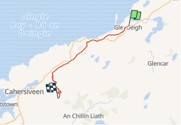
Glenbeigh - Derrymore

bffcuc
Gebruiker

Lengte
26 km

Max. hoogte
330 m

Positief hoogteverschil
730 m
Km-Effort
36 km

Min. hoogte
13 m

Negatief hoogteverschil
653 m
Boucle
Neen
Datum van aanmaak :
2014-12-11 00:00:00.0
Laatste wijziging :
2014-12-11 00:00:00.0
8h15
Moeilijkheid : Onbekend

Gratisgps-wandelapplicatie
 SityTrail
IGN / Geografische instituten
SityTrail Plus
De wereld gaat voor u open
Over ons
Tocht Andere activiteiten van 26 km beschikbaar op Onbekend, County Kerry, Kenmare Municipal District. Deze tocht wordt voorgesteld door bffcuc.
Plaatsbepaling
Land:
Ireland
Regio :
Onbekend
Departement/Provincie :
County Kerry
Gemeente :
Kenmare Municipal District
Locatie:
Glanbehy
Vertrek:(Dec)
Vertrek:(UTM)
435729 ; 5767787 (29U) N.
Opmerkingen